
During this incredible, giant descent we'll bike and raft a total distance of 272km/169mi with an elevation difference of 4773m/15658ft! Our highest point at 5110m/16765ft takes us from andean highland "altiplano" tundra, llama and alpaca country down through puna grassland, through high jungle scrub and into lower, lush tropical jungle. This is mostly downhill and planned for limiting hike-a-bike and strenuous uphill battles. It's also mostly singletrack with a combination of double, dirt and very little paved roads. We'll bike through the coca-chewing highland communities of the Andes, down through subtropical mining town and even further down into the agricultural areas along the jungles of the Inambari River.
Duration
Total Dist
Max Elev
Min Elev
Elev Change
Difficulty
Raft Dist
Rapids Class
Rafting Duration
River Speed
Biking Distance
Bike/Raft Chgs
River Water
Bugs?
8-9D
272km/169mi+
5110m/16765ft
337m/1107ft
4773m/15658ft
3-4 of 5
71km/44mi
1-2+
7-8hrs+
6-13kph/4-8mph
201km/125mi+
2-3
Murky
No/Yes
Day 1 Lake Sabinacocha (Ausangate) - Corani - Tantamaco Camp
From Cusco we'll either take a private van to Lake Sabinacocha or a public bus to Sicuani then a private van from Sicuani up to Sabinacocha. When we reach the highest point just above the lake we can begin our descent on bikes. We head towards the east on a dirt road and spend the next few hrs descending from 5110m/16765ft down through high altitude valleys, through the pueblo of Corani, then up and towards the south on singletracks towards Tantamaco where we will find a picturesque (but cold) campsite near the "bosque de piedras" (rock forests) of Corani at ~14000ft. Night tent camping.
Day 2 Macusani - Allincapac (Cordillera Carabaya) Lakeside Camp
This morning we'll ascend slightly towards the south on more singletrack reaching the larger town of Macusani at 14224ft. From here we continue uphill towards the east on paved roads with beautiful views of the Carabaya mountain range and snow-capped peaks of Mt. Allincapac where we'll camp next to one of multiple high lakes between 4572-4267m/15000-14000ft. Night tent camping.
Day 3 Ayapata - Balconpata Camp
Today we begin the real descent of our trip. Now heading north we lose 1000ft in elevation every 2-3mi. We have the choice of a dirt road with switchbacks or single track to the west side. Soon we enter a valley and the district of Ayapata which now turns east again, losing the barren, rocky terrain of the altiplano and beginning to turn greener. Our singletrack takes us into a narrower valley, passing by and through agricultural plots until we reach subtropical scrub near an area called Balconpata where we'll find a campsite. Night tent/hammock camping.
Day 4-7 Bancomayo - Inambari R. Camping
Having left behind the higher altitude the challenge now becomes finding our way. This morning we'll reach a hydroelectric station and a trail which leads us further down switchbacks, across a river and eventually joins the road which leads us further down to Bancomayo, a community nestled into the spurs and crux of the mountains which are covered in high jungle vegetation. The roads and trails now switchback up and down different spurs creating a maze. We turn now to the west to cross a bridge which takes us to connecting singletracks through another 20mi of high jungle descent. We will pass through sparse agricultural areas and follow the river down to the navigable Inambari River at 532m/1745ft. This route from Bancomayo to the Inambari is all singletrack and has some ascents and may take as many as 2-3 days. Nights hammock camping.
Day 8-9 Inambari R. packrafting - Mazuko
At the Inambari river bank we'll inflate our boats and disassemble our bikes to pack them on our boats before rafting 71km/44mi through Peruvian Amazon jungle along the Bahuaja Sonene National Park to our take out point near Mazuko. The rafting portion could last 7-8hrs and 1-2 days. After landing south of Mazuko we'll deflate our boats and pack them on our bikes for a 4mi+ bike ride north to Mazuko and the bus terminal for a transfer to either Cusco or Puerto Maldonado.
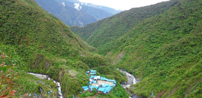 Bancomayo pueblo of Ituata
Cost Estimates
A private van transfer to the beginning of our trip at Sabinacocha will be shared by the group. Any possible hostal stays along the way should cost from S/20-40 soles per night. Food purchased at Peruvian supermarkets can be about $10 per day. Return bus transportation from Mazuko to Cusco typically ranges from S/40-70 Soles. There are no entrance fees for this trip. There are no fees for our agency for any of these expeditionary trips, no guide fees and also no guarantees on return times, points of interest or the assurance of any planned activities.
Gear
You will need to provide your own gear for this trip including bike, bags, packraft, PFD, paddles, bug hammock, tarp, sleeping bag, cook kit and food. You will also need both warmer mountain and cooler tropical clothing a well as bug protection. Both a tent and hammock are highly recommended or a dual use tarp + hammock + mesh tent would be ideal. In the case that you cannot provide your own equipment contact us for options. Please purchase a can or 2 or canned oxygen "Oxishot" in Cusco prior to the trip.
Risks
Good brakes are required due to the rate and duration of the descent. ACCLIMATE! Please stay a minimum of 2 days in Cusco prior to the trip. Cusco is just above 11,000 ft and we will pedaling and camping at elevations which are much higher! The popular Ausangate trek would be a fair comparison for the first half of the journey. This trip should not be attempted during rainy season (Dec - March) when rain and water levels can become unpredictable. The ideal time for this route is from May 15th - Nov 15th when the river is tame and the bike route is drier and less cumbersome. This also allows for any potential landslides and road clearings to have already passed. Other potential dangers in the lower elevations are people hurting themselves with their own machetes, falling on uneven ground, ant bites, mosquito bites, allergic reactions etc. In most cases it may take days to reach the nearest clinic or "Centro de Salud" for any needed medical attention. We offer no guarantees for any of these expeditions for planned activites, definite costs or for your absolute safety.
Options
An additonal + 3-4 day route is possible from Sabinacocha to the south then east through the heart of the "Bosque de Piedras de Corani" (Rock Forest) and Canadian mining company of "Bear Creek" to Macusani. Both Macusani and Ayapata may have hostals available. There will be small stores with food and drinks available in the towns. From Mazuko the Madre de Dios river is within biking distance as well as the Tambopata Bikerafting Expedition.


